
Walk Six - Ledbury and Eastnor
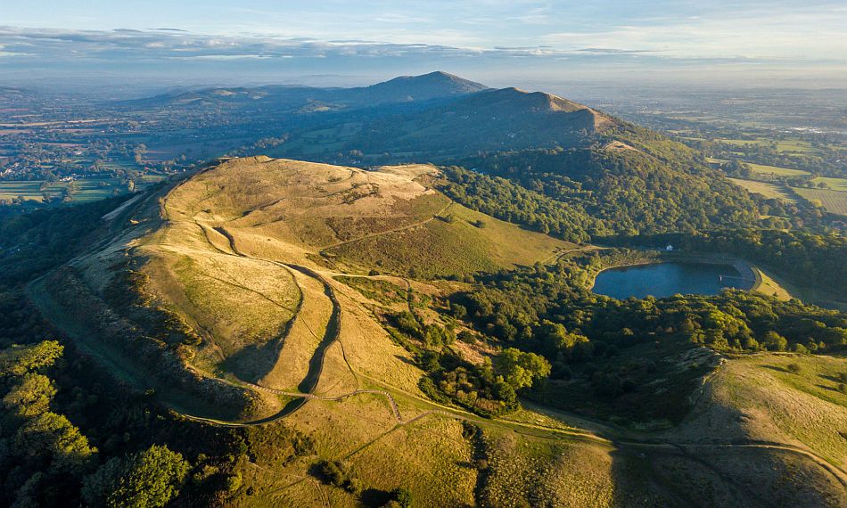
The image at the top of the page shows Herefordshire Beacon and British Camp reservoir from above Clutter’s Cave on its southern slope.
An extravagant ley starting in the Beacons
As we discover in Walk One, it came to him in a flash. What Hereford man Alfred Watkins perceived was “like a chain of fairy lights”, a series of lines linking ancient features such as mounds, moats, hill forts, standing stones, wayside crosses and churches. He was convinced that Britain was interlaced by a vast network of straight trackways and proposed Leylines in The Old Straight Track of 1925. In his list of initial sighting points, he was now including beacons for the first time. The previous year saw him put forward an extravagant alignment: It ran from Clutter’s Cave, visited on Walk Four, on the Eastnor side of Herefordshire Beacon; then through the “sacrificial stone” to Woolhope Church, from there to the church and a pond at Holme Lacy, and through Aconbury Church to finish on the highest point of Aconbury camp, five miles south of Hereford.
Our sixth Watkins Walk gives a southern perspective of the Malvern Beacons which are pictured on our Home page. The pre-historic purpose of a beacon was to guide and direct. In the case of Midsummer Hill, seen from our point 4, an excavation by Watkins had revealed a platform beneath the surface where beacon fires were shown to have burned. Watkins believed that old tracks across a ridge were there not because they can be seen from below, but specifically because they provide easy travelling and are often carefully situated to conceal travellers from observers below.
First and foremost Alfred Watkins, born at the Imperial Hotel in Hereford's Widemarsh Street, was an archaeologist and an inventor of photographic equipment. His fascination with photography began with a primitive pinhole camera which he made from a cigar box. He patented the “exposure meter”, a device which contributed greatly to photography’s evolution as a mass-market art form.
When Watkins was in his mid-20s, he learned that the Hereford and Gloucester canal was going to be closed to make way for the train. Accordingly he set out with a companion on a canoe expedition of the waterway’s 34 miles to capture pictures for posterity.
At the same time, in 1881 or 1882, the budding Poet Laureate John Masefield was a small child living in Ledbury at a commodious Victorian house called the Knapp. From his seat in a big bow window he could see the canal about 200 yards below the family garden, an orchard, a field and a clump of elms with a great rookery.
For their two day excursion, the canoeists alighted for the night in Bye Street at the Ledbury Town Wharf (near our point 1). The wharf, which was soon to be subsumed, is the setting for Masefield’s work The Widow in the Bye Street introducing a young navvy hero who was employed on building the railway.
Alfred Watkins himself had become a familiar face in Ledbury as an agent for his father’s brewery and spirits business. Among his friends was John Edy Ballard, of the Frith. His uncles Stephen and Philip Ballard had supervised the creation of the Ledbury to Hereford section of the canal. Another Ballard brother, Robert, owned the company which baked the five million bricks from which Ledbury Viaduct was built. Spanning the Leadon Valley, the 31 arches can be seen from several points on our moderate, undulating ramble over varied terrain.
The lady appointed to carry out the grand opening ceremony in June 1861 was unfortunately left behind at Hereford Station by excited officials. Another special train was speedily commissioned to pick her up, and the said Mrs Richards was able to lay the last of Mr Ballard’s bricks with the band playing See The Conquering Hero.
website designed and maintained
by Hereford Web Design